


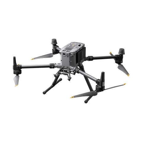
Versatile & tough.
DJI has engineered the M350 RTK to be designed for harsh conditions. The M350 boasts a IP55 rating meaning it can survive dust and water being thrown at it from any direction. All arms and arm connectors are sealed against external factors.

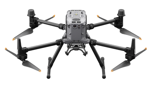
Expansive payload options.
The M350 can carry a wide variety of DJI payloads as well as third party payloads. The M350 is primarily used in tandem with the Zenmuse P1 for photogrammetry applications, as well as the Zenmuse L2 for LiDAR mapping missions.

Impressive flight qualities.
The M350 RTK can deal with almost any weather conditions. DJI has rated the M350 RTK to fly between -20C all the way to +50C making at a great choice for places with poor weather conditions. The M350 RTK also has a max wind resistance rating of 12m/s which further boosts its ability to perform regardless of weather,

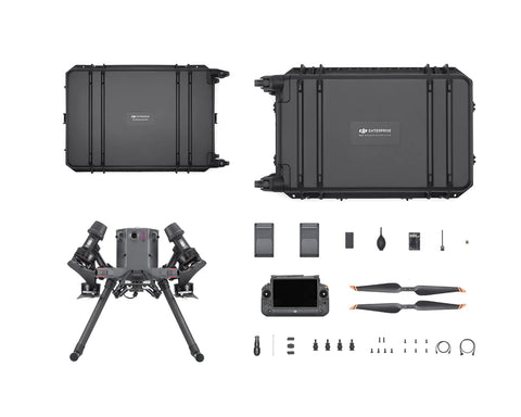
DJI Pilot 2.
The RC Plus from DJI comes standard with Pilot 2, this software allows pilots to monitor the health of there aircraft, plan missions and do so much more. Pilot 2 is the ultimate software suite for all pilots experienced or not.
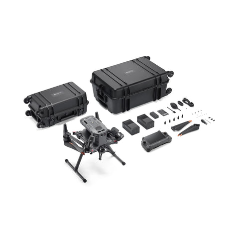
Purchase the M350 RTK today,
Tech Specs.
M350 RTK specifications are listed below,- Dimensions (unfolded, without propellers)
810×670×430 mm (L×W×H)
- Dimensions (folded, with propellers)
430×420×430 mm (L×W×H)
- Diagonal Wheelbase
895 mm
- Weight (with single downward gimbal)
Without batteries:
Approx. 3.77 kg
With two TB65 batteries:
Approx. 6.47 kg
- Single Gimbal Damper’s Max Payload
960 g
- Max Takeoff Weight
9.2 kg
- Operating Frequency
2.4000-2.4835 GHz
5.150-5.250 GHz (CE: 5.170-5.250 GHz)
5.725-5.850 GHz
In some countries and regions, the 5.1GHz and 5.8GHz frequency bands are prohibited, or the 5.1GHz frequency band is only allowed for indoor use. Please refer to local laws and regulations for more information.
- Transmitter Power (EIRP)
2.4000-2.4835 GHz:
< 33 dBm (FCC)
< 20 dBm (CE/SRRC/MIC)
5.150-5.250 GHz (CE: 5.170-5.250 GHz):
< 23 dBm (CE)
5.725-5.850 GHz:
< 33 dBm (FCC/SRRC)
< 14 dBm (CE)
- Hovering Accuracy (with moderate or no wind)
Vertical:
±0.1 m (with vision positioning)
±0.5 m (with GNSS positioning)
±0.1 m (with RTK positioning)
Horizontal:
±0.3 m (with vision positioning)
±1.5 m (with GNSS positioning)
±0.1 m (with RTK positioning)
- RTK Positioning Accuracy (RTK FIX)
1 cm + 1 ppm (horizontal)
1.5 cm + 1 ppm (vertical)
- Max Angular Velocity
Pitch: 300°/s
Yaw: 100°/s
- Max Pitch Angle
30°
When in N mode and with the forward vision system enabled: 25°.
- Max Ascent Speed
6 m/s
- Max Descent Speed (vertical)
5 m/s
- Max Tilted Descent Speed
7 m/s
- Max Horizontal Speed
23 m/s
- Max Flight Altitude
5000 m
When using the 2110s propellers and with the takeoff weight ≤ 7.4 kg.
7000 m
When using the 2112 High-Altitude Low-Noise Propellers and with the takeoff weight ≤ 7.2 kg.
- Max Wind Speed Resistance
12 m/s
- Max Flight Time
55 minutes
Measured with Matrice 350 RTK flying at approximately 8 m/s without payloads in a windless environment until the battery level reached 0%. Data is for reference only. Actual usage time may vary depending on the flight mode, accessories, and environment. Please pay attention to reminders in the app.
- Supported DJI Gimbals
Zenmuse H20, Zenmuse H20T, Zenmuse H20N, Zenmuse P1, and Zenmuse L1
- Third-Party Payload
Supports only certified payloads developed based on DJI Payload SDK.
- Supported Gimbal Configurations
Single downward gimbal
Single upward gimbal
Dual downward gimbals
Single downward gimbal + single upward gimbal
Dual downward gimbals + single upward gimbal
- Ingress Protection Rating
IP55
The IP rating is not permanently effective and may decrease due to product wear and tear.
- Global Navigation Satellite System
GPS + GLONASS + BeiDou + Galileo
- Operating Temperature
-20° to 50° C (-4° to 122° F)
- Screen
7.02-inch LCD touchscreen; resolution: 1920×1200; max brightness: 1200 nits
- Weight
Approx. 1.25 kg (without WB37 battery)
Approx. 1.42 kg (with WB37 battery)
- Global Navigation Satellite System
GPS + Galileo + BeiDou
- Built-in Battery
Type: Li-ion (6500 mAh@7.2 V)
Charging Type: Use the battery station or USB-C fast charger with a max power of 65 W (max voltage of 20 V).
Charging Time: 2 hours
Chemical System: LiNiCoAlO2
- External Battery (WB37 Intelligent Battery)
Capacity: 4920 mAh
Voltage: 7.6 V
Type: Li-ion
Energy: 37.39 Wh
Chemical System: LiCoO2
- Ingress Protection Rating
IP54
- Operating Time
Built-in Battery: approx. 3.3 hours
Built-in Battery + External Battery: approx. 6 hours
- Operating Temperature
-20° to 50° C (-4° to 122° F)
- Operating Frequency
2.4000-2.4835 GHz
5.725-5.850 GHz
- Transmitter Power (EIRP)
2.4000-2.4835 GHz:
< 33 dBm (FCC)
< 20 dBm (CE/SRRC/MIC)
5.725-5.850 GHz:
< 33 dBm (FCC)
< 14 dBm (CE)
< 23 dBm (SRRC)
- Wi-Fi Protocol
Wi-Fi 6
- Wi-Fi Operating Frequency
2.4000-2.4835 GHz
5.150-5.250 GHz
5.725-5.850 GHz
- Bluetooth Protocol
Bluetooth 5.1
- Bluetooth Operating Frequency
2.4000-2.4835 GHz
- Video Transmission System
DJI O3 Enterprise Transmission
- Antenna
4 video transmission antennas, 2T4R
- Max Transmission Distance (unobstructed, free of interference)
20 km (FCC)
8 km (CE/SRRC/MIC)
- Max Transmission Distance (with interference)
Low Interference and Obstructed by Buildings: approx. 0-0.5 km
Low Interference and Obstructed by Trees: approx. 0.5-3 km
Strong Interference and Unobstructed: urban landscape, approx. 1.5-3 km
Medium Interference and Unobstructed: suburban landscape, approx. 3-9 km
Low Interference and Unobstructed: suburb/seaside, approx. 9-20 km
Measured with FCC compliance in unobstructed environments with typical interference at a flight altitude of approximately 120 m. Data is for reference only. The actual transmission distance may vary depending on the environment’s obstruction and interference conditions. Please pay attention to reminders in the app.
- Obstacle Sensing Range
Forward/Backward/Left/Right: 0.7-40 m
Upward/Downward: 0.6-30 m
- FOV
Forward/Backward/Downward: 65° (horizontal), 50° (vertical)
Left/Right/Upward: 75° (horizontal), 60° (vertical)
- Operating Environment
Surfaces with discernible patterns and adequate lighting (lux > 15)
- Input
100-240 V AC, max 8 A
- Output
26.4 V, 7.8 A
- Total Rated Output
476 W, including 65W PD fast charging of USB-C port
- Charging Time
Fast Mode: Approx. 35 minutes to 90%
Standard Mode: Approx. 55 minutes to 100%
Silent Mode: Approx. 80 minutes to 100%
Tested at a room temperature of 25° C (77° F) and in a well-ventilated environment. In Fast mode, each battery pair is charged to 90% in sequence, and then eight batteries are charged together to 100%.
- Charging Temperature
-20° to 40° C (-4° to 104° F)
- Weight
Approx. 1,680 g
- Obstacle Sensing Range
0.1-8 m
- FOV
30° (±15°)
- Operating Environment
Large, diffuse, and reflective obstacles (reflectivity > 10%)
- Resolution
1080p
- FOV
142°
- Frame Rate
30fps
- Dimensions
580×358×254 mm (L×W×H)
- Net Weight
Approx. 8.98 kg
- Compatible Stored Items
Eight TB65 Intelligent Flight Batteries
Four WB37 Intelligent Batteries
- Input Voltage
100-120 VAC, 50-60 Hz
220-240 VAC, 50-60 Hz
- Max Input Power
1070 W
- Output Power
100-120 V: 750 W
220-240 V: 992 W
- Operating Temperature
-20° to 40° C (-4° to 104° F)